There was a question in the Sql Server Spatial/Katmai forums about why a straight line on a sphere didn't "look straight".
Katmai both have planar and spherical geometry types. The spherical type makes it easier to handle things like straight lines, distances and areas over large distances, and depending on which type you choose, you can get very different results.
Consider traveling on a straight line from Vancouver to Frankfurt. They are both located roughly at latitude 50°N. So the line would follow latitude 50°N right? Well that's true for a planar coordinate system:
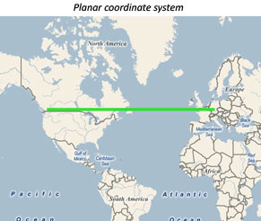
So according to The Flat Earth Society (who actually believes the Earth is flat) the green line above shows the shortest distance between the two cities. But what we are actually seeing is an artifact of working with a planar coordinate system depicting a world that is not planar.
Using a spheric coordinate system, we get a different result. When looking at this line in a projected coordinate system, like the Mercator projection I've used here, the line doesn't look straight (left image below). However if we look at this in a 3D view (right image), it becomes apparent that the "curved line" is actually the shortest line between the two cities.
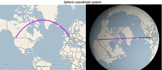
The difference between using the two geometry types gets really apparent when you try to find the shortest distance from New York to the line in the two coordinate systems. In the planar case, Quebec is approximately the point where the line is the closest to New York. In the spherical case, the line never gets closer to New York than from Vancouver where it started out.
Another way that I like to think of why following a latitude is not the shortest route, is imagining two guys standing a few feet from the North Pole with the pole between them. Which way is the shortest path between them: Walking straight over the pole or following the latitude at 89.999°N around it? Now imagine how this line would look on a map.
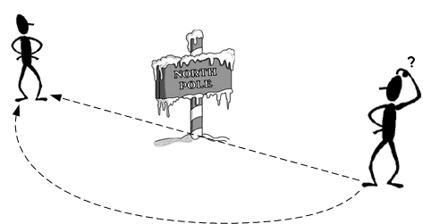
We can extend this further and have the two men go further and further away from each other. If one man gets a little further south than the other, the line wouldn't pass the pole, but go by just next to the it - it still wouldn't follow the latitude. Since the North Pole is just a point we humans "made up", we can abstract it and think of a pole in the ground anywhere on Earth. The bottom line is that the North Pole and the latitudes are all imaginary, and doesn't really exist, and definitely doesn't help describing the shortest distance.
Only at Equator would it be a good idea to follow the latitude, which is because this is the only latitude that is a great circle, and it so happens to be that any straight line between two points will describe parts of a great circle. Longitudes however are all great circles, and the line between the two men describe parts of a longitude. The reason we think that the horizontal line between Vancouver and Germany is the shortest path, is simply because we have to project the round Earth onto a flat piece of paper, and this causes all sorts of things to get distorted.